|
| Gallery Site Map | Home |
|
This Info List is under permanent construction...
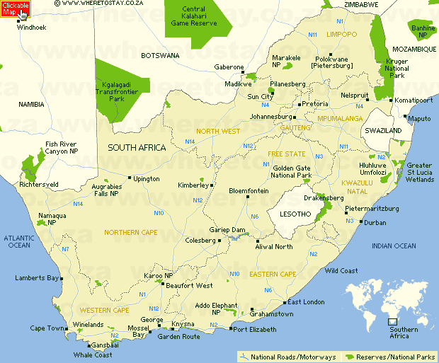
* * * * * The Western Cape is a province in the south west of South Africa. The capital is Cape Town. * * * * * Cape TownCape Town (Kaapstad in Afrikaans) is the third most populous city in South Africa. * * * * * Northern CapeThe Northern Cape is a large, sparsely populated province of South Africa, created in 1994 when the Cape Province was split up. Its capital is Kimberley. * * * Vanrhynsdorp areaVanrhynsdorp is situated about 300 km north of Cape Town, south of Namaqualand, in the Succulent Karoo Biome. The vegetation is dominated by dwarf, succulent shrubs, of which the Vygies (Mesembryanthemaceae) and Stonecrops (Crassulaceae) are particularly prominent. The peculiar habitat of Knersvlakte is covered in many places with small glistening quartz stones. The vegetation consists of very low shrubs and plants, like Living Stones. * * * CederbergThe Cederberg mountains are located near Clanwilliam, approximately 300 km north of Cape Town. The mountain range is named after the endangered Clanwilliam Cedar (Widdringtonia cedarbergensis), which is a tree endemic to the area. The mountains are noted for dramatic rock formations and San rock art. The presented slides originate also from a broader surrounding (e.g. Pakhuis Pass situated more to the north). * * * Harold Porter National Botanical GardenA citation from its homepage: This beautiful, secluded garden is set between mountain and sea, in the heart of the Cape fynbos region and encompasses 10 hectares of cultivated fynbos garden and 190 hectares of pristine natural fynbos. It is 100 kilometres east from Cape Town on the coastal road. * * * Robberg Nature and Marine ReserveA citation from CapeNature.org.za: The Robberg Peninsula is a nature reserve and national monument that lies on Garden Route. The reserve is situated in an overlapping region of winter and summer rainfall. There is an increased likelihood of showers between August and November. The ecology of the Robberg Peninsula is similar to that of other rocky headlands on this coastline. It presents a fine example of how plants and animals adapt to the interacting influences of land and sea. * * * De Hoop Nature ReserveAn brief info from CapeNature.org.za: Only three hours from Cape Town lies a special nature reserve situated in the Overberg region, near the southern tip of Africa. De Hoop Nature Reserve is approximately 34'000 ha in size. The adjacent De Hoop Marine Protected Area, which extends three nautical miles (5 km) out to sea, is one of the largest marine protected areas in Africa and provides a sanctuary for a vast array of marine life. A typical Mediterranean climate prevails in the region; summers are warm and winters mild. De Hoop Nature Reserve forms part of the Cape Floral Kingdom and fynbos is the dominant vegetation group. * * * Nature's ValleyNature's Valley is a small village situated at the mouth of the Groot River and forms part of the Tsitsikamma De Vasselot nature reserve. * * * Tsitsikamma National Park
* * * * * NamibiaNamibia is a country north of Sout Africa on the Atlantic coast. It gained independence from South Africa in 1990 and its capital city is Windhoek. * * * * * Free StateThe Free State is an inland province of South Africa. The name is a popular contraction of the previous name the Orange Free State. Its capital is Bloemfontein. * * * * * Easthern CapeThe Eastern Cape is a province of South Africa. It was formed in 1994 out of the "independent" homelands of Transkei and Ciskei, as well as the eastern portion of the Cape Province. Its capital is Bhiso. * * * * * KwaZulu NatalKwaZulu-Natal, is a province of South Africa situated on the coast of Indian Ocean. * * * * * DrakensbergThe Drakensberg are the highest mountains in Southern Africa, rising up at Thabana Ntlenyana to 3,482 m in height. They are located in the eastern part of South Africa, running for some 1,000 km generally southwest to northeast, with a northwesterly bend forming the northeastern border of Lesotho with South Africa. They are drained on the west by the Orange and Vaal rivers, and on the east and south by a number of smaller rivers, the Tugela being the largest. The range thus separates KwaZulu-Natal Province from Free State Province, looming over the nearby coast of Natal. * * * * * LesothoThe Kingdom of Lesotho is a land-locked country, entirely surrounded by the Republic of South Africa. Formerly Basutoland, it is a member of the Commonwealth of Nations. The name Lesotho roughly translates into "the land of the people who speak Sotho." The most notable geographic fact about Lesotho, apart from its status as an enclave, is that it is the only independent state in the world that lies entirely above 1,000 meters in elevation. Its lowest point is 1,400 metres, and over 80% of the country lies above 1,800 metres. * * * * * Pics for friends !Here you find |
| Total images: 1209 | Last update: 04-10-2006 21:26 | Generated by JAlbum 6.5 & Chameleon skin | Full Screen projection | Help |


